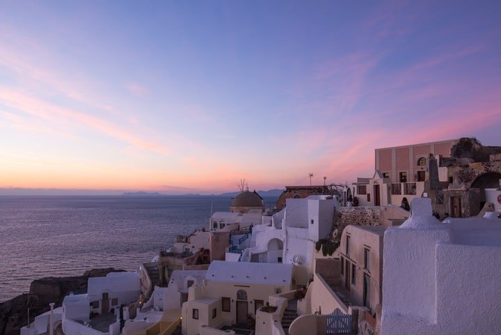
I often think about what Bali was like in the past,” is a sentiment frequently expressed on Indonesia’s most famous vacation island. Renowned for its vibrant green rice fields and breathtaking beaches, the “island of the Gods” has experienced significant changes over the last fifty years, with both locals and visitors voicing concerns about traffic, pollution, and unruly tourists that have accompanied the influx of hotels and resorts now dominating the landscape. As the Indonesian government seeks to limit further development on the island, newly released and declassified satellite images from 1965 illustrate the extent of Bali’s transformation.
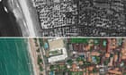
These images, featured in an interactive map by Nusantara Atlas, depict how the once peaceful coastlines of popular areas like Seminyak and Canggu have evolved from quiet spots into bustling hubs filled with shopping centers, large resorts, and villas stretching as far as the eye can see. David Gaveau, founder of Nusantara Atlas and an environmental scientist who lived in Bali for over a decade, aims to contribute to the conversation surrounding overtourism and rapid development. “Everyone recognizes that Bali has changed; we just didn’t know the specifics,” he remarked. “Now we can visualize it.”
Captured by the Cold War-era US spy satellite KH-7 Gambit in May 1965, the images focus on the southern coastal region from Uluwatu to just south of Ubud. This satellite, operational from 1963 to 1967, was the first in the US to consistently deliver high-resolution photographs. The pre-digital films were collected midair by specially equipped aircraft near Hawaii and then processed on Earth. Originally, the satellite primarily orbited over Soviet territory to photograph missile silos and other strategic targets.
Years later, these images reveal another narrative of development in Southeast Asia, where tourism has significantly altered the landscape and lifestyle. Gaveau noted the significance of the timing, as Bali’s international airport opened just a few years later in 1968, igniting the tourism boom that has made the island one of Asia’s most popular destinations. According to Indonesia’s statistics bureau, Bali’s population has grown from around 2 million in the 1960s to over 4 million today. Government data indicates that approximately half a million tourists visit the island each month, with an increasing number of digital nomads also arriving.
Bali’s provincial government aims to achieve a record 6.5 million international tourists this year. Ida Bagus Aria Yoga Dharata, from the Bali environmental organization Walhi, stated that the map would assist in advocating for environmental conservation in Bali. “People are drawn here because of the culture… The Balinese have a deep connection to nature, each other, and God, and there is no other place like this,” Dharata expressed. “If that connection is lost, then Bali becomes just like anywhere else.”
Chakra Widia, a Balinese conservationist, mentioned that many farmers no longer view agriculture as a viable option and are instead selling their land for villas.